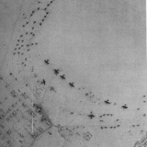
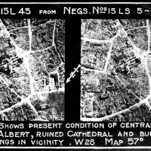
" I'm fairly certain that is not Ste. Mere Eglise. I was recently there and the road patterns just do not match. Also, on June 6 there was a large fire at one corner of the church square and I don't see that damage. I'm guessing it might be one of the villages nearby. Check a current image of Ste. Mere Eglise on Google Earth, I think you'll agree. The church is even a different shape"
This is Sainte-Marie-du-Mont which is north of Carentan, and SouthEast of Sainte-Mere-Eglise. Great photo though. I'm pretty sure if was one of the first towns off Utah Beach on the way to Sainte-Mere-Eglise and Carentan so would be an important village to hold.
Wonderful photo and information clarifying the exact location.
I have been looking through all the other aerial photos in this gallery too, amazing pictures, thanks to the members that uploaded them
We are a non commercial community interested only in the discussion of all things military.
We do not sell or authorise the use of images hosted on our servers, if you wish to purchase or use imagery contact the uploader directly.(you will need to register). Any requests received to purchase or use imagery will be ignored. Thank you and welcome to MI.Net
You have been here as a guest for a while, I guess we are doing something right?
Register as a member and join in the discussions, its completely free and we would welcome your contributions.
All the best admin - MI.Net
We value your privacy
We use essential cookies to make this site work, and optional cookies to enhance your experience.